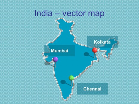
Here is the next in our range of maps – a vector map of India.
It can be used in PowerPoint slides, in web pages and blogs, or anywhere else where it might be helpful. At the moment we have maps of UK & Europe, also we have free editable PowerPoint maps of North America and now editable world maps.
If you liked this PowerPoint Template we would appreciate you liking it on FaceBook or Tweeting it.
Published On: 22nd Dec 2010
Read more about -Editable Map PowerPoint Templates , Asia Maps, Geography, India, Maps Template number 00206
-
the map in incomplete, it doesnt shows the northern section properly, pls correct it.
-
I don’t they really know about. This map is a copy paste from some other website.
-
It is not a copy and paste we did this map ourselves and traced it out.
What section are we missing?
-
Please see the Survey of India website to know the exact configuration of this map. Please don’t ever refer to CIA factbook for map references.
-
Thanks we will check it out.
-
We have now updated the maps of India to reflect the North
-
Its Great and it helped me out for my college presentation….
-
Fantastic – I am so grateful to you. Will pass on the word around.
-
Thank you… your map was useful
-
Thanks for Down load.
It will be more useful with States incorpoarted -
It was really Helpful. Thanks a ton.
-
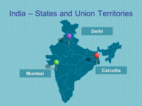
We have now updated the maps of India to reflect the States and Union Territories
-
So happy to find this site. I work for an NGO and this is exactly what we needed for a visualization.
-
This is awesome…and really usful stuff for presentations…Thanks
-
Extremely useful! Thanks 🙂
-
This is a very useful ppt – i am preparing a ppt for my child on indian culture and heritage. Thanks a lot and keep it up !
-
thanks a lot folks..!!ur work is just awsome..exactly wat i was looking for..!Thanks a trillion..!
-
Thanks a lot….This is what I was looking for my program…Now you have my job simple and most attractive…Once again thank you very much
Thangarajan.P.k
-
Thank you Sir. This map has helped me a lot
-
Thanks
-
The map does not show the Island territories. Could you add that.
-
Hi.. Could you add the new state of Telengana? Thanks
-
Hi
I believe Assam is missing from the Map and please update the map for Telangana.
Thanks
-
I am a student and needed help with a map for my report.Thank you so much!
-
Can you please include add Telangana, the newly created state in the map?
Thanks!
-
can you advice how to i show a state from India map for explaining the state economy
-
Thank you so much. This is exactly what I was looking for. It will be very helpful for newcomers working with Presentation.
-
Thanks.. its really helpful..
-
Can you please include New State “Telangana” in map.
-
Thank you it is very nice
-
Hey ! I loved the specifics . Does someone know if I would be able to acquire a blank Canada OPG 5521 version to complete ?
-
Very useful for Presentation maker
-
Good Work, very help full..
-
Do we need copyright to publish these maps in scientific journal ?